Google added image-generation AI to Google Earth and rolled it back after just one day.
On July 30, 2026, Google introduced a new feature for Google Earth on the web that allowed users to generate custom images using Google Earth’s satellite, aerial and 3D imagery together with Nano Banana. Users could zoom into a place, click “create image” and type a prompt describing what they wanted to see.
The examples were attractive.
A vacant lot could become a community garden.
The ruins of Pompeii could be reimagined as a Roman street in 78 AD.
An empty site in Tokyo could be visualized as a shopping and retail district.
A modern cabin could be added beside a lake.
Google presented the tool as useful for historical education, place exploration, real-estate planning, architecture, urban design and personal project visualization.
On the surface, this was an exciting product feature.
Google Earth shows real places.
Nano Banana generates images.
When the two are combined, users can place the past, the future, a plan or an imagined scene on top of real geography. A map is no longer only something to observe. It becomes a canvas for imagination, planning and explanation.
But the next day, Google pulled the feature back.
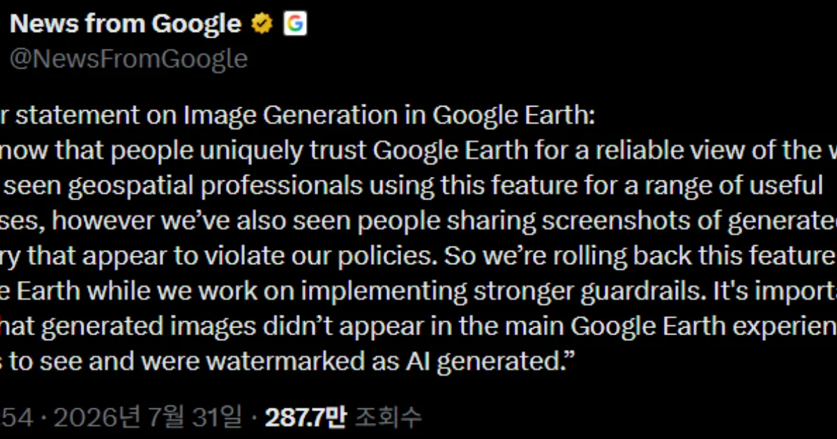
Reuters reported that Google temporarily halted the feature after some users shared generated images that appeared to violate Google’s policies. Google said the generated images were watermarked and did not appear in the core Google Earth experience, but the company paused the tool while it works on stronger safeguards.
The rollback says something important.
AI image generation is not only a question of what a model can create.
It is a question of where the model is placed.
When the service is built on trust in reality, AI imagination immediately becomes risk.
Google Earth Was Not Originally a Creative Tool
Google Earth is not an ordinary image-editing app.
People use Google Earth to see the planet. They inspect cities, roads, rivers, mountains, borders, coastlines, buildings and terrain. Students use it to learn geography. Travelers use it to preview destinations. Professionals use it for planning, environmental analysis, real-estate review, research, disaster response and exploration.
The core value of Google Earth is reality.
Users assume that what they see is based on the physical world. Satellite imagery, aerial imagery, 3D terrain and building renderings may not always be perfectly current or perfectly accurate, but users understand them as observations of real places.
That trust is the product’s main asset.
When generative AI enters that environment, the nature of the service changes.
A user can look at a real place and create a scene that is not real. A ruin can become an ancient city. A vacant lot can become a futuristic shopping district. An ordinary campus can become a cyberpunk city. A lakefront can become a luxury resort.
As a creative function, this is appealing.
Inside a map service, it can create confusion.
Is this image real?
Is it a proposal?
Is it a fantasy?
Is it an educational reconstruction?
Is it a marketing rendering?
Is it political manipulation?
Is it a distorted image of a disaster, conflict or development site?
An AI image inside Google Earth is not just a beautiful picture.
It is a picture attached to a real place.
That makes it more persuasive than ordinary synthetic imagery.
Images on maps feel like evidence.
What the One-Day Rollback Revealed
Google originally introduced the feature through productive examples.
Teachers could show students a historical reconstruction of Pompeii.
Users could create an infographic about the Statue of Liberty.
Architects and planners could reimagine an empty site in Tokyo as a vibrant retail district.
Individuals could visualize an eco-friendly cabin on a lakeside property.
Users could also play creatively by turning favorite places into futuristic scenes.
The problem is real-world use.
AI features are not used only as designers intend. People use them for jokes, exaggeration, satire, manipulation, political messages, commercial promotion and viral screenshots.
That becomes more dangerous when the base layer is a real location.
Google appeared to recognize that quickly. According to Reuters, the company said some users shared screenshots of generated images that seemed to violate its policies. Even though those images were not displayed inside the default Google Earth experience and were watermarked, Google rolled the feature back.
That means Google did not treat the risk as minor.
Once a generated image leaves the product as a screenshot, control weakens. A watermark can be cropped, blurred, compressed or ignored. Context can disappear. People may not study the label. They may simply remember that the image came from Google Earth.
In the AI era, the key issue is not only where content is created.
It is where content travels.
Why AI Images on Maps Are More Dangerous
AI image generation already exists across many services.
People can type prompts to create images, edit photos, change backgrounds or add objects and people. That is no longer surprising.
But generative imagery inside Google Earth creates a different category of risk.
The reason is place.
A generic AI image is often understood as fiction. But when an image is tied to a specific address, building, school, religious site, border, war zone, disaster area or residential neighborhood, it becomes more sensitive.
A user could make an area look destroyed.
A user could distort a religious facility.
A user could make a company’s property appear polluted.
A user could depict a residential area as dangerous.
A user could make a speculative development look like an approved plan.
A user could manipulate war, protest or disaster imagery.
A map-based image can look less like imagination and more like a claim about reality.
That is the dilemma for Google Earth.
Give users imagination, and education, planning and simulation become more powerful.
Give users imagination inside a trusted map, and the same feature can support misinformation, defamation, fear, propaganda, real-estate deception or local discrimination.
When AI-generated imagery is attached to geography, creation and evidence begin to blur.
The Tool Could Be Powerful for Education and Urban Planning
The feature is not inherently bad.
In fact, Google’s examples were compelling.
Historical education can benefit from visual reconstruction. Students may understand Pompeii more deeply if they can see the ruins reimagined as a living Roman street rather than only as archaeological remains.
Urban planning and architecture can also benefit.
A vacant lot can be visualized as a park, housing complex, cultural facility, retail district or green building. For public meetings, client presentations or design discussions, a visualization placed on top of real terrain is easier to understand than an abstract drawing.
Real estate, landscape design, tourism planning and environmental restoration could also use this kind of tool.
Disaster preparedness and climate education may benefit as well. A coastal area could be shown under a sea-level-rise scenario. A wildfire-damaged landscape could be visualized with a restoration plan. Urban heat-island mitigation could be shown through tree coverage or reflective surfaces.
The direction is not wrong.
The problem is safeguards.
Map-based AI generation needs stronger context labels, usage limits, watermarking, export controls, sensitive-place filters and policy enforcement than ordinary image generation.
Google’s rollback should be read less as a rejection of the idea and more as an admission that the initial safeguards were not enough.
AI Watermarks Are Not Enough
Google said generated images were watermarked as AI-generated.
That is important.
But it is not sufficient.
A watermark works only when the image remains intact. Screenshots can be cropped. Images can be recompressed. A user can share only part of the output. The watermark may be unclear on another platform. Many viewers may not notice it.
More importantly, a watermark only says that an image was generated by AI.
It does not fully explain the relationship between the image and reality.
A historical reconstruction needs to say whether it is based on evidence or pure imagination.
A real-estate visualization needs to say whether it is an approved development, a concept, or a user-generated fantasy.
A future-city image needs to say whether it is a prediction, a design scenario, or a playful prompt result.
For a service like Google Earth, a simple “AI-generated” label is not enough.
The system needs richer context labels:
actual satellite image;
AI-generated concept;
educational historical reconstruction;
user-created visualization;
unapproved development concept;
non-official personal image.
Without these distinctions, users may misunderstand what they are seeing.
In a map service, reality labeling must be more precise than ordinary AI labeling.
Google Earth’s Trust Is Part of Google’s Larger Trust System
Google’s fast rollback also reflects the broader value of Google Earth’s trust.
Google Earth, Google Maps, Street View, Search and Gemini are all connected to Google’s role as a gateway to information about the real world. People use Google to find places, navigate streets, verify local information, inspect images and understand geography.
If generated imagery in Google Earth creates confusion, the risk extends beyond one experimental feature.
Geographic information is sensitive.
Borders, military sites, public buildings, schools, hospitals, religious facilities, homes, disaster zones and conflict areas can all become socially or politically charged when distorted. A feature that looks like playful image generation can acquire serious meaning when tied to a real location.
Google appears to understand this.
Rolling back a feature after one day is not easy in a competitive AI market. But if Google Earth’s core asset is trust, a careless expansion of AI could cost more than a temporary pause.
In AI product strategy, speed matters.
But the ability to stop matters too.
When Generative AI Enters Reality Interfaces
This incident shows where generative AI is heading.
Until recently, AI generation features mostly lived inside creative tools: image generators, video editors, design apps, writing assistants and chatbots. Users understood that these environments were built for creation.
Now generative AI is entering reality interfaces.
Maps.
Search.
Shopping.
Real estate.
Education.
Medicine.
Finance.
Public services.
Urban planning.
These services were not originally designed as fiction machines. They help users understand, verify and make decisions about the real world.
When generative AI enters those systems, productivity rises, but the boundary between reality and fiction weakens.
Google Earth’s Nano Banana feature is an early example.
It placed AI imagination on top of real geography. That can support visualization and simulation. It can also look like manipulation of reality, especially when screenshots travel outside the original product context.
The next challenge for generative AI is not simply making more realistic images.
It is explaining what reality those images are attached to.
The Real-Estate and Urban-Planning Risks
Google explicitly mentioned real estate and urban planning as use cases.
A vacant site could be imagined as a retail district. A lakeside property could be visualized with a modern cabin.
This is useful.
Developers, architects, planners, local governments, residents and investors all need to imagine possible futures for land. AI visualization can make that easier.
But this domain is full of conflicts of interest.
An AI-generated development image can look like an approved plan.
A real-estate ad can show an exaggerated future.
A generated image can make the view, traffic, greenery, public facilities or surrounding environment look better than they are.
A controversial development can be visually framed in a way that softens opposition.
On a map, such images become highly persuasive.
That means regulation and disclosure matter.
An AI-generated development visualization should clearly state whether it is an official plan, a private proposal, a user-created concept or a fantasy. It should not be confused with zoning approval, land ownership, environmental clearance or government planning.
Google Earth-based AI visualization could become a powerful real-estate tool.
It could also become a powerful exaggeration tool.
Historical Reconstruction Also Requires Caution
Historical visualization has similar risks.
Recreating Pompeii as a Roman street in 78 AD can be educationally powerful. Students may better understand the past when they see a place as it may once have appeared.
But historical reconstruction always involves interpretation.
Is the image based on archaeological evidence?
Is it based on scholarly reconstruction?
Which details are inferred?
Which details are imagined?
Does it distort a culture, period or community?
Could students remember the image as fact?
Images are powerful in education. They often remain in memory more strongly than text. When an AI-generated historical scene is placed on top of a real site in Google Earth, its persuasive force increases.
AI does not show the past itself.
It generates an interpretation of the past.
That distinction must be clear.
Why Policy-Violating Images Can Spread Quickly
Google said some users shared screenshots that appeared to violate its policies. It did not specify the exact content.
But the categories of possible risk in map-based image generation are broad.
Hate imagery.
Violence.
Sexual content.
Distortion of public facilities.
Fake disasters.
Fake war damage.
Political manipulation.
Privacy violations.
Defamation.
Encouragement of illegal activity.
Such images can spread quickly because they are visually strong, location-based and associated with a trusted map product. On social media, shock travels faster than context.
Safeguards must therefore consider not only generation, but also sharing.
Sensitive places may need stricter generation limits.
High-risk prompts should be blocked.
Exports should carry durable labels.
Commercial uses may require separate disclosure.
Professional and educational access may need different rules from consumer access.
Google’s rollback suggests the company needs to redesign this control layer.
Lessons for Korean Companies and Public Institutions
This case has clear implications for Korean companies and public agencies.
Generative AI will increasingly be added to maps, real-estate services, urban-planning tools, tourism platforms, education services, environmental dashboards, disaster-response systems and national-land-management platforms.
A tool may visualize a redevelopment project.
It may reconstruct a cultural heritage site.
It may show a flooded neighborhood under a climate scenario.
It may turn a tourist destination into future content.
These uses can be valuable.
But the Google Earth case shows that reality-based services require stricter rules than ordinary content services.
Actual images and AI-generated images must be clearly separated.
The purpose and assumptions of AI-generated images must be stated.
Official information and user-created imagination must not be mixed.
Sensitive locations and private residences may require generation limits.
Commercial real-estate and development visualizations need anti-misleading-advertising controls.
Labels should survive screenshots and external sharing as much as possible.
Public institutions should be especially careful.
If a government or local authority shows AI-generated images on a public map, citizens may interpret them as official plans. A redevelopment rendering, disaster forecast, heritage restoration or urban-regeneration image can damage policy trust if it appears more certain, more approved or more optimistic than it really is.
AI visualization is an explanation tool.
Used poorly, it becomes persuasion by illusion.
When AI Changes Maps, Trust Must Be Redesigned
Google Earth’s Nano Banana feature was an important experiment.
It showed that real places can become canvases for history, planning, design, education and imagination. With generative AI, users can move beyond seeing the world as it is and begin visualizing how it was, how it might be or how it could be explained.
But Google rolled the feature back after one day.
That decision does not reject generative AI.
It shows that the capability is powerful enough to require more caution.
Google Earth is a service people use to check reality. When AI-generated imagery appears on top of it, the output is not just a picture. It can become a claim that looks grounded in the real world.
Google said the generated images did not appear in the default Google Earth experience and were watermarked. But once screenshots are shared, context can disappear. The very fact that people trust Google Earth makes synthetic images more risky.
AI-era maps now face new questions.
Does the map show reality?
Does it show possibility?
Does it show imagination?
Does it show an official plan?
Who created the scene?
What assumptions shaped it?
Can users distinguish fact from fiction?
For generative AI to enter maps safely, image generation is not enough.
Trust design is required.
Context labels are required.
Sharing controls are required.
Sensitive-place protections are required.
Interfaces must clearly separate reality from imagination.
Google Earth’s one-day AI image experiment is important because it showed both sides of the future.
AI can help us imagine the world more richly.
It can also make us believe the world wrongly.
A map can become a creative canvas.
But before that, it is trust infrastructure.